South Carolina Lowcountry
The Lowcountry is a geographic and cultural region located along South Carolina's coast. The region includes the South Carolina Sea Islands. Once a location that was known for its agricultural wealth, the Lowcountry today is internationally renowned for its historic cities and communities, its natural beauty, and its unique cultural heritage, which have attracted millions of visitors and thousands of new residents.
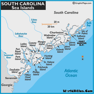
Sea Islands in Charleston County:
|
|
Start in Charleston
Precise boundaries for the Low Country are unclear, but Charleston is generally agreed to be its largest economic center. Begin your trip on the edge of the historic district with a stroll down East Bay Street; on one side you'll see some of Charleston's historic architecture, from Italianate to art deco, and on the other, across the harbor, Fort Sumter, where the first shot of the Civil War was fired. For your first taste of the South, try the shrimp and grits fritters at High Cotton (www.mavericksouthernkitchens.com/highcotton)
while live jazz plays.
The Angel Oak
Head out of Charleston on Route 17 south. After about 15 miles (24 kilometers), turn left on Main Road and continue eight miles (13 kilometers) to the Angel Oak, a 65-foot (20-meter)-tall live oak tree estimated to be around 300 years old. It's had enough time to grow a canopy that shades 17,000 square feet (1,579 square meters).
Edisto Island
Continue south on Route 17 before turning left onto Highway 174, the live oak-lined road to Edisto Island. On this tranquil island, without a single traffic light, the most visible commerce for miles might be a roadside stand run by Gullah women—descendants of the Low Country's first black inhabitants—weaving and selling coiled sweetgrass baskets. Stop at the Serpentarium (edistoserpentarium.com) to see reptiles from the region and beyond in low-walled enclosures (not behind glass) for optimal viewing. Photos, old farm implements, and a reconstructed plantation room relate the island's past at the tiny Edisto Island Museum (www.edistomuseum.org). Eventually, Highway 174 loops around a quiet beach, a favorite of shell collectors; the southern end, where the ocean meets the South Edisto River, boasts the best sunset views.
Beaufort
Farther along Route 17 south, take Route 21 to Beaufort, South Carolina's second-oldest city (after Charleston), and, before the Civil War, perhaps one of the wealthiest towns of its size in the country. Check in at the Rhett House Inn (www.rhetthouseinn.com), an antebellum plantation home, and pedal one of their bikes around the waterfront and historic homes.
St. Helena Island
Route 21 south continues on to St. Helena Island and Penn Center (www.penncenter.com), the country's first school for African Americans. The 50-acre (20 hectare) campus is preserved as a National Historic Landmark; a small museum displays photos, letters, and Gullah artwork. Up the road is the Red Piano Too Art Gallery (www.redpianotoo.com), its rooms brimming with a collection of paintings, sculpture, woodwork, and jewelry by local artists. For local food, including she-crab soup and sweet potato pie, cross the street to Gullah Grub (www.gullahgrubs.com).